| Page last updated
Sun 07 Sep 2025 |
The Freshwater Mussels (Unionoida) of the World (and other less consequential bivalves)
FM(U)otW(aolcb) is the web version of the MUSSEL Project Database. Follow the links to browse the data or use the custom Google search field. Either way, you win!
This page reports the specimens in the MUSSELpdb and provides a map if geocodes are known. The taxonomic history reports the record of different names and combinations that have been applied to this species (and its synonyms) since 2007. The MUSSEL Project Database has moved to a new server, with a new URL! The new address for this page is: https://musselpdb.org/db.php?ty=validsp&id=1107
Search the database pages:
|
|
Bivalvia | Unionoida | Etherioidea | Mycetopodidae | Anodontitinae | Anodontites species Anodontites cylindracea (Lea, 1838): specimens
6 nominal species as synonyms
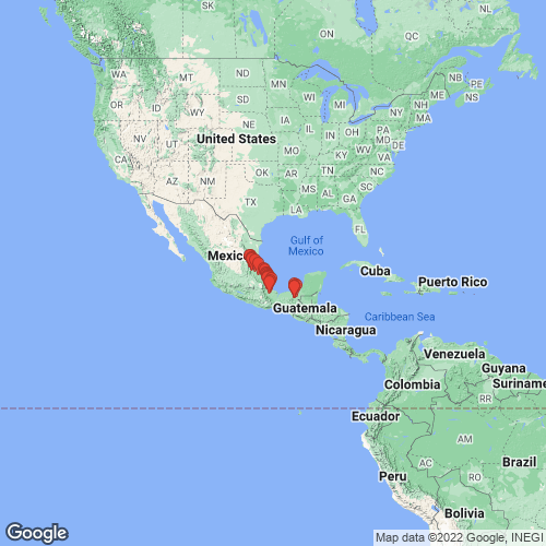
Range: States of Chiapas and Vera Cruz, Mexico. Map of Georeferenced Specimens
 |
Mexico |

USNM_1282313
Veracruz, river ca. 1.5-2 rivermiles above bridge of Rt. Mex. 180 (ca. 3.7 roadmiles N of central square of Cardel) above Gloria (in an area locally called Real del Oro Vero). N19°25'00" W96°22'30" 10 Feb 82 and 14 Feb 82
|

USNM_25433
Vera Cruz, Mexico
|

FMNH_3292
stream, near the ruins of Palenque, Chiapas, Mexico
|

USNM_1282307
Veracruz, Rio Cotaxtla (upper Rio Atoyac) at Rt. Ver. 149 in Cotaxtla (turn-off to road to Cotaxtla from Rt. Mex. 140 is ca. 26.1 roadmiles SW of divergence of Rt. Mex, 150 and Rt. Mex. 140 S of Veracruz
|

USNM_251190
Lake, Playa de Catasaja, Tabasco, Mexico
|

USNM_1282308
Veracruz, Rio Jamapa at road to Medellin at El Tejar, ca. 5.3 roadmiles from junction of this road with Rt. Mex. 140, S of Veracruz (city)
|

INHS_20435
Rio Casas Viejas, N of Valles, San Luis Potosi, Mexico
|

SMF_11954
Rio Michol, b. Palenque, Chiapas, Mexiko
|

ANSP_129933
Alvarado R., [=Rio Papaloapam] Mexico
|

INHS_90950
Rio Michol, Gulf of Mexico - Grijalva - Usumacinta - Tulija - Michol, 6.9 mi WSW Palenque, near ruins in cow pasture, Chiapas, Mexico
|

ZMB_16687
Rio de Misantla
|

BMNH_1965146
rivulos prope vicum Palenqueanum prov. Chiapa[Mexico].
|

USNM_86712
Riv. Medellin, Vera Cruz, Mexico
|

INHS_91076
Rio Saguila, Gulf of Mexico - Grijalva - Usumacinta - Chacamax, SE Emiliano Zapata, off Rt. 10, fish camp, Tabasco, Mexico
|

ANSP_61626
Forrest of San Juan, near Vera Cruz, Mexico
|

USNM_1282309
Veracruz, Rio Papaloapan off road from Ciudad Aleman to Tuxtepec; ca. 0.5 roadmiles by dirt road to river; dirt road entrance to Aleman-Tuxtepec road is ca. 2.4 roadmiles W of divergence of roads to Ciudad Aleman and Cosamaloapan
|

USNM_1282310
Veracruz, spillway pool off left side of Rio Papaloapan along Rt. Mex. 175 in Cosamaloapan
|

INHS_20436
Tampamolon Creek, Tampamolon, [San Luis Potosi], Mexico
|

ZMB_4272
Medellin Fl., Vera Cruz
|

USNM_1282311
Veracruz, river ca. 2.7 roadmiles upriver from La Gloria, where dirt road crosses river, N of Cardel
|

INHS_89436
Rio Tampaón [22 km SSW of Ciudad Valles, 38 km S of Tamuin, 132 km WSW of Tampico], San Luis Potosi, Mexico
|

ANSP_99552
Tampamolone Creek, S.L. Potosi, Mexico
|

USNM_1282306
Rio Tamuin [Tampaón], at Mex. 85 just S of Alvero Obregon, S of Ciudad Valles, San Luis Potosi, Mexico.
|

UMMZ_248946
Rio Paso de Milpa, 5.4 km NNE Rinconada, Antigua, Veracruz, Mexico
|

UMMZ_248947
Rio Paso de Quejas, Paso de Oujas, Veracruz, Mexico
|

UMMZ_248948
Rio Nautla, Paso Largo, 10.9 km ENE Martinez de la Torre, Veracruz, Mexico
|

UMMZ_248949
creek, 9 mi WNW Alamo, Veracruz, Mexico
|

UF_225824
Valles River, W of Micos, Mexico
|

USNM_1282312
Veracruz, Rio Tempoal (or Rio Calabazo) at Rt. Mex. 105 between Tempoal and Platon Sanchez. N21°25'00" W98°23'30" 8 Feb 82
|
|
|
Page updated: 08:19:29 Sun 07 Sep 2025 |
|