|
Unionoida | Unionoidea | Unionidae | Ambleminae | Lampsilini | Lampsilis species Lampsilis teres (Rafinesque, 1820): specimens
11 nominal species as synonyms
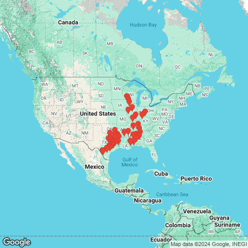
Range: Widespread in rivers of the Interior Basin and Gulf Coastal Plain, USA. Map of Georeferenced Specimens
 |
Mexico |

USNM_123632
Rio Grande, Tamaulipas, Mexico
|
|
|
|
ZMA_419274 Mexico
|
USA |

USNM_30023A
Ohio R., Sedamsville, Ohio
|
|
|
|
INHS_89410
|
Genbank Vouchers
USAJFBM_22431_5 (SK16055) (COI, ND1, ITS1, 5.8S) Cache River, 5.5 miles W Buncombe, Mt Pleasant Rd. Bridge, Union Co, IL (37.466389, -89.076667) JFBM_22428_1 (SK16021) (COI, ND1, ITS1, 5.8S) Saline River, 3 river miles downstream of Longview Boat Access, Ashley Co. AR (33.346099, -91.983193) UF_438887 (LterAla034) (COI, ITS1, 5.8S, 18S) Alabama River at Robert F. Henry Lock Chamber, RM 245.4, 6.7 km W of White Hall (32.32302, -86.78344) JFBM_22435_4 (SK16070) (COI, ND1, ITS1, 5.8S) Mississippi River at Harper's Slough, Allamakee Co. IA (43.18511554, -91.14455717) JFBM_22431_6 (SK16056) (COI, ND1, ITS1, 5.8S) Cache River, 5.5 miles W Buncombe, Mt Pleasant Rd. Bridge, Union Co, IL (37.466389, -89.076667) TAMU-NRI_8174_1 (SK16097) (COI, ND1, ITS1, 5.8S) Brazos River, Fort Bend Co. TX (29.645447, -95.95335) INHS_89410 (COI, ND1, ITS1, 5.8S) Wabash River, 2.1 mi SSE Calvin, I-64 bridge, White Co. IL (38.2286, -87.98511) JFBM_22430_6 (SK16048) (COI, ND1, ITS1, 5.8S) Hatchie River, TN 3.8 miles southeast of Bolivar, 200 meters upstream of Hwy 64 TWRA boat ramp, Hardeman Co. TN (35.241403, -88.922461) UF_438887 (LterAla036) (COI, ITS1, 5.8S, 18S) Alabama River at Robert F. Henry Lock Chamber, RM 245.4, 6.7 km W of White Hall (32.32302, -86.78344) JFBM_22425_7 (SK16015) (COI, ND1, ITS1, 5.8S) Black Warrior River, Halfway between Lock & Dam 5 & 6, Hale Co. AL (32.631697, -87.811349) JFBM_22425_3 (SK16011) (COI, ND1, ITS1, 5.8S) Black Warrior River, Halfway between Lock & Dam 5 & 6, Hale Co. AL (32.631697, -87.811349) JFBM_22435_2 (SK16068) (COI, ND1, ITS1, 5.8S) Mississippi River at Harper's Slough, Allamakee Co. IA (43.18511554, -91.14455717) JFBM_22422_5 (SK16006) (COI, ND1, ITS1, 5.8S) Bogue Chitto Creek, Hwy 22 Bridge Crossing, Dallas Co. AL (32.30629, -87.28015) TAMU-NRI_8030_2 (SK16084) (COI, ND1, ITS1, 5.8S) San Jacinto River, San Jacinto Co. TX (30.42734, -95.12647) TAMU-NRI_8136_1 (SK16090) (COI, ND1, ITS1, 5.8S) Rio Grande, Webb Co. TX (27.732917, -99.776275) JFBM_22422_6 (SK16007) (COI, ND1, ITS1, 5.8S) Bogue Chitto Creek, Hwy 22 Bridge Crossing, Dallas Co. AL (32.30629, -87.28015) JFBM_22431_3 (SK16053) (COI, ND1, ITS1, 5.8S) Cache River, 5.5 miles W Buncombe, Mt Pleasant Rd. Bridge, Union Co, IL (37.466389, -89.076667) JFBM_22421_1 (SK15001) (COI, ND1, ITS1, 5.8S) Mississippi River at Beaver Island, Clinton Co. IA (41.796955, -90.21958) TAMU-NRI_8165_5 (SK16094) (COI, ND1, ITS1, 5.8S) Guadalupe River, Victoria Co. TX (28.830712, -97.055658) JFBM_22427 (SK16020) (COI, ND1, ITS1, 5.8S) Okatibbee Reservoir, East of Collinsville @ Gin Creek Access, Lauderdale Co. Mississippi (32.521786, -88.808334) JFBM_22422_4 (SK16005) (COI, ND1, ITS1, 5.8S) Bogue Chitto Creek, Hwy 22 Bridge Crossing, Dallas Co. AL (32.30629, -87.28015) JFBM_22435_1 (SK16067) (COI, ND1, ITS1, 5.8S) Mississippi River at Harper's Slough, Allamakee Co. IA (43.18511554, -91.14455717) JFBM_22425_6 (SK16014) (COI, ND1, ITS1, 5.8S) Black Warrior River, Halfway between Lock & Dam 5 & 6, Hale Co. AL (32.631697, -87.811349) TAMU-NRI_8329_4 (SK168329_4) (COI, ND1, ITS1, 5.8S) Colorado River - NE of Altair, Colorado Co. TX (29.67159, -96.458137) TAMU-NRI_8136_2 (SK16091) (COI, ND1, ITS1, 5.8S) Rio Grande, Webb Co. TX (27.732917, -99.776275) UF_438887 (LterAla037) (COI, ITS1, 5.8S, 18S) Alabama River at Robert F. Henry Lock Chamber, RM 245.4, 6.7 km W of White Hall (32.32302, -86.78344) TAMU-NRI_8165_10 (SK16095) (COI, ND1, ITS1, 5.8S) Guadalupe River, Victoria Co. TX (28.830712, -97.055658) TAMU-NRI_8137_2 (SK16093) (COI, ND1, ITS1, 5.8S) Rio Grande, Webb Co. TX (27.722883, -99.76258) JFBM_22421_2 (SK15002) (COI, ND1, ITS1, 5.8S) Mississippi River at Beaver Island, Clinton Co. IA (41.796955, -90.21958) TAMU-NRI_8052_1 (SK16085) (COI, ND1, ITS1) Neches River, Tyler/Jasper Co. TX (30.643163, -94.051707) UF_440982 (LterGua017) (COI, ND1, ITS1) Guadalupe River at Hwy 77 crossing (28.83164, -97.05937) UF_440982 (LterGua018) (COI, ND1, ITS1) Guadalupe River at Hwy 77 crossing (28.83164, -97.05937) UF_441218 (COI, ITS1, 5.8S) USA, Texas, Washington County, Navasota River, 1 mile S of Hwy 105, near Navasota, TX (30.3546667, -96.1416362) UF_439427 (SK19146) (COI, ND1) West Pearl River; 180 air m SW of confluence of Bennet Bayou and Old Pearl River, St. Tammany Parish, LA (30.46459, -89.7712) UF_438309 (SK19132) (COI, ND1) Pascagoula River at Paper Mill Camp slough about 2 mi. upstream of MS Hwy 614, Jackson Co. MS (30.63228, -88.652401) UF_439144 (SK19139) (COI, ND1) Bogue Chitto River near Lock 2, St. Tammany Parish, LA (30.62254, -89.87655) UF_439427 (SK19144) (COI, ND1) West Pearl River; 180 air m SW of confluence of Bennet Bayou and Old Pearl River, St. Tammany Parish, LA (30.46459, -89.7712) JFBM_22428_4 (SK16024) (COI, ND1) Saline River, 3 river miles downstream of Longview Boat Access, Ashley Co. AR (33.346099, -91.983193) JFBM_22428_3 (SK16023) (COI, ND1) Saline River, 3 river miles downstream of Longview Boat Access, Ashley Co. AR (33.346099, -91.983193) INHS_39037 (LfraIll027) (COI, ND1) Illinois River, 4.7 mi ESE Griggsville, I-72 bridge (39.68618, -90.64155) Mp_4235_SK15010 (COI, ND1) Mississippi River at Beaver Island, Clinton Co. IA (41.796955, -90.21958) JFBM_22428_9 (SK16029) (COI, ND1) Saline River, 3 river miles downstream of Longview Boat Access, Ashley Co. AR (33.346099, -91.983193) UF_438309 (SK19135) (COI, ND1) Pascagoula River at Paper Mill Camp slough about 2 mi. upstream of MS Hwy 614, Jackson Co. MS (30.63228, -88.652401) UF_438309 (SK19130) (COI, ND1) Pascagoula River at Paper Mill Camp slough about 2 mi. upstream of MS Hwy 614, Jackson Co. MS (30.63228, -88.652401) JFBM_22429_2 (SK16039) (COI, ND1) Duck River, TN 0.7 miles northeast of Columbia, 50 meters upstream of Riverside Drive boat ramp, Maury Co. TN (35.618385, -87.024758) TAMU-NRI_8030_1 (SK16083) (COI, ND1) San Jacinto River, San Jacinto Co. TX (30.42734, -95.12647) TAMU-NRI_8137_1 (SK16092) (COI, ND1) Rio Grande, Webb Co. TX (27.722883, -99.76258) JFBM_22431_4 (SK16054) (COI, ND1) Cache River, 5.5 miles W Buncombe, Mt Pleasant Rd. Bridge, Union Co, IL (37.466389, -89.076667) JFBM_22430_8 (SK16050) (COI, ND1) Hatchie River, TN 3.8 miles southeast of Bolivar, 200 meters upstream of Hwy 64 TWRA boat ramp, Hardeman Co. TN (35.241403, -88.922461) JFBM_22425_1 (SK16009) (COI, ND1) Black Warrior River, Halfway between Lock & Dam 5 & 6, Hale Co. AL (32.631697, -87.811349) JFBM_22429_4 (SK16041) (COI, ND1) Duck River, TN 0.7 miles northeast of Columbia, 50 meters upstream of Riverside Drive boat ramp, Maury Co. TN (35.618385, -87.024758) UF_439144 (SK19142) (COI, ND1) Bogue Chitto River near Lock 2, St. Tammany Parish, LA (30.62254, -89.87655) UF_438309 (SK19134) (COI, ND1) Pascagoula River at Paper Mill Camp slough about 2 mi. upstream of MS Hwy 614, Jackson Co. MS (30.63228, -88.652401) UF_438899 (SK19149) (COI, ND1) Pine Creek, ~100 m upstream from CR906, Lamar Co. TX (33.854656, -95.341305) UF_438309 (SK19133) (COI, ND1) Pascagoula River at Paper Mill Camp slough about 2 mi. upstream of MS Hwy 614, Jackson Co. MS (30.63228, -88.652401) JFBM_22422_1 (SK16002) (COI, ND1) Bogue Chitto Creek, Hwy 22 Bridge Crossing, Dallas Co. AL (32.30629, -87.28015) JFBM_22425_9 (SK16017) (COI, ND1) Black Warrior River, Halfway between Lock & Dam 5 & 6, Hale Co. AL (32.631697, -87.811349) JFBM_22431_1 (SK16051) (COI, ND1) Cache River, 5.5 miles W Buncombe, Mt Pleasant Rd. Bridge, Union Co, IL (37.466389, -89.076667) JFBM_22428_6 (SK16026) (COI, ND1) Saline River, 3 river miles downstream of Longview Boat Access, Ashley Co. AR (33.346099, -91.983193) JFBM_22428_2 (SK16022) (COI, ND1) Saline River, 3 river miles downstream of Longview Boat Access, Ashley Co. AR (33.346099, -91.983193) UF_438309 (SK19137) (COI, ND1) Pascagoula River at Paper Mill Camp slough about 2 mi. upstream of MS Hwy 614, Jackson Co. MS (30.63228, -88.652401) UF_438899 (SK19151) (COI, ND1) Pine Creek, ~100 m upstream from CR906, Lamar Co. TX (33.854656, -95.341305) UAUC_6 (COI, 16S) Yellowleaf Creek, Coosa Drainage, Alabama JFBM_22430_7 (SK16049) (COI, ND1) Hatchie River, TN 3.8 miles southeast of Bolivar, 200 meters upstream of Hwy 64 TWRA boat ramp, Hardeman Co. TN (35.241403, -88.922461) UF_439144 (SK19140) (COI, ND1) Bogue Chitto River near Lock 2, St. Tammany Parish, LA (30.62254, -89.87655) TAMU-NRI_8165_11 (SK16096) (COI, ND1) Guadalupe River, Victoria Co. TX (28.830712, -97.055658) UF_439427 (SK19147) (COI, ND1) West Pearl River; 180 air m SW of confluence of Bennet Bayou and Old Pearl River, St. Tammany Parish, LA (30.46459, -89.7712) JFBM_22429_1 (SK16038) (COI, ND1) Duck River, TN 0.7 miles northeast of Columbia, 50 meters upstream of Riverside Drive boat ramp, Maury Co. TN (35.618385, -87.024758) JFBM_22428_8 (SK16028) (COI, ND1) Saline River, 3 river miles downstream of Longview Boat Access, Ashley Co. AR (33.346099, -91.983193) Mp_4235_SK15011 (COI, ND1) Mississippi River at Beaver Island, Clinton Co. IA (41.796955, -90.21958) JFBM_22430_1 (SK16043) (COI, ND1) Hatchie River, TN 3.8 miles southeast of Bolivar, 200 meters upstream of Hwy 64 TWRA boat ramp, Hardeman Co. TN (35.241403, -88.922461) JFBM_22435_3 (SK16069) (COI, ND1) Mississippi River at Harper's Slough, Allamakee Co. IA (43.18511554, -91.14455717) UF_438899 (SK19150) (COI, ND1) Pine Creek, ~100 m upstream from CR906, Lamar Co. TX (33.854656, -95.341305) UF_438309 (SK19138) (COI, ND1) Pascagoula River at Paper Mill Camp slough about 2 mi. upstream of MS Hwy 614, Jackson Co. MS (30.63228, -88.652401) TAMU-NRI_8052_4 (SK16088) (COI, ND1) Neches River, Tyler/Jasper Co. TX (30.643163, -94.051707) TAMU-NRI_8447_3 (SK168447_3) (COI, ND1) Colorado River - NE of Altair, Colorado Co. TX (29.67159, -96.458137) UF_439144 (SK19141) (COI, ND1) Bogue Chitto River near Lock 2, St. Tammany Parish, LA (30.62254, -89.87655) JFBM_22430_5 (SK16047) (COI, ND1) Hatchie River, TN 3.8 miles southeast of Bolivar, 200 meters upstream of Hwy 64 TWRA boat ramp, Hardeman Co. TN (35.241403, -88.922461) UF_438968 (SK19152) (COI, ND1) Big Cypress Bayou (just downstream from Hwy 59, near Jefferson, TX), Marion Co. TX (32.739928, -94.441666) JFBM_22431_2 (SK16052) (COI, ND1) Cache River, 5.5 miles W Buncombe, Mt Pleasant Rd. Bridge, Union Co, IL (37.466389, -89.076667) UF_438899 (SK19148) (COI, ND1) Pine Creek, ~100 m upstream from CR906, Lamar Co. TX (33.854656, -95.341305) UF_438309 (SK19131) (COI, ND1) Pascagoula River at Paper Mill Camp slough about 2 mi. upstream of MS Hwy 614, Jackson Co. MS (30.63228, -88.652401) JFBM_22434 (SK16066) (COI, ND1) Timber Creek, 3.6 miles NE McLean, Co. Rd 535N, Funks Grove, McLean Co. IL (40.36061, -89.13652) JFBM_22425_10 (SK16018) (COI, ND1) Black Warrior River, Halfway between Lock & Dam 5 & 6, Hale Co. AL (32.631697, -87.811349) JFBM_22425_4 (SK16012) (COI, ND1) Black Warrior River, Halfway between Lock & Dam 5 & 6, Hale Co. AL (32.631697, -87.811349) UF_438968 (SK19153) (COI, ND1) Big Cypress Bayou (just downstream from Hwy 59, near Jefferson, TX), Marion Co. TX (32.739928, -94.441666) JFBM_22428_10 (SK16030) (COI, ND1) Saline River, 3 river miles downstream of Longview Boat Access, Ashley Co. AR (33.346099, -91.983193) TAMU-NRI_8381_1 (SK168381_1) (COI, ND1) Rio Grande, upstream of La Bota, Laredo Webb Co. TX (27.60224, -99.58051) JFBM_22425_8 (SK16016) (COI, ND1) Black Warrior River, Halfway between Lock & Dam 5 & 6, Hale Co. AL (32.631697, -87.811349) JFBM_22429_3 (SK16040) (COI, ND1) Duck River, TN 0.7 miles northeast of Columbia, 50 meters upstream of Riverside Drive boat ramp, Maury Co. TN (35.618385, -87.024758) UF_439144 (SK19143) (COI, ND1) Bogue Chitto River near Lock 2, St. Tammany Parish, LA (30.62254, -89.87655) UF_439427 (SK19145) (COI, ND1) West Pearl River; 180 air m SW of confluence of Bennet Bayou and Old Pearl River, St. Tammany Parish, LA (30.46459, -89.7712) JFBM_22422_3 (SK16004) (COI, ND1) Bogue Chitto Creek, Hwy 22 Bridge Crossing, Dallas Co. AL (32.30629, -87.28015) JFBM_22428_7 (SK16027) (COI, ND1) Saline River, 3 river miles downstream of Longview Boat Access, Ashley Co. AR (33.346099, -91.983193) JFBM_22425_2 (SK16010) (COI, ND1) Black Warrior River, Halfway between Lock & Dam 5 & 6, Hale Co. AL (32.631697, -87.811349) JFBM_22430_4 (SK16046) (COI, ND1) Hatchie River, TN 3.8 miles southeast of Bolivar, 200 meters upstream of Hwy 64 TWRA boat ramp, Hardeman Co. TN (35.241403, -88.922461) JFBM_22430_2 (SK16044) (COI, ND1) Hatchie River, TN 3.8 miles southeast of Bolivar, 200 meters upstream of Hwy 64 TWRA boat ramp, Hardeman Co. TN (35.241403, -88.922461) TAMU-NRI_8223_1 (SK16098) (COI, ND1) Brazos River, Brazos/Washington Co. TX (30.378934, -96.161204) JFBM_22425_5 (SK16013) (COI, ND1) Black Warrior River, Halfway between Lock & Dam 5 & 6, Hale Co. AL (32.631697, -87.811349) JFBM_22429_5 (SK16042) (COI, ND1) Duck River, TN 0.7 miles northeast of Columbia, 50 meters upstream of Riverside Drive boat ramp, Maury Co. TN (35.618385, -87.024758) JFBM_22428_5 (SK16025) (COI, ND1) Saline River, 3 river miles downstream of Longview Boat Access, Ashley Co. AR (33.346099, -91.983193) JFBM_22422_2 (SK16003) (COI, ND1) Bogue Chitto Creek, Hwy 22 Bridge Crossing, Dallas Co. AL (32.30629, -87.28015) JFBM_22430_3 (SK16045) (COI, ND1) Hatchie River, TN 3.8 miles southeast of Bolivar, 200 meters upstream of Hwy 64 TWRA boat ramp, Hardeman Co. TN (35.241403, -88.922461) UF_438309 (SK19129) (COI, ND1) Pascagoula River at Paper Mill Camp slough about 2 mi. upstream of MS Hwy 614, Jackson Co. MS (30.63228, -88.652401) TAMU-NRI_8052_5 (SK16089) (COI, ND1) Neches River, Tyler/Jasper Co. TX (30.643163, -94.051707) UF_439490 (LterSab167) (COI) Lake Fork Creek downstream of SH 49, 4.3 km WSW of Hainesville, TX (32.70236, -95.40663) UF_440997 (LterCol025) (COI) Colorado River at FM 950; just east of Garwood, TX; sampled ~30m stretch along right ascending bank near old bridge abutments. (29.45354, -96.39587) INHS_35066_2 (COI) Cache River (Ohio) (37.466389, -89.076667) Mp_4235_LterAla053 (COI) Gravid female used for propagation collected from Big Swampy Creek at US Hwy 80; progeny cultured at AL Aquatic Biodiversity Center, Marion, AL (32.26707, -86.69463) UF_439472 (LterBra156) (COI) Brazos River in overbank habitat at Brazos Park East, 100m transect along East shoreline (31.58727, -97.15311) UF_439489 (LterSab164) (COI) Sabine River 2.7 km NW of Logansport, LA (31.991656, -94.017535) UF_439489 (LterSab163) (COI) Sabine River 2.7 km NW of Logansport, LA (31.991656, -94.017535) INHS_35066_1 (COI) Cache River (Ohio) (37.466389, -89.076667) UF_439484 (LterBra160) (COI) New City Lake along east shoreline, 5.4 km NE of Marlin, TX (31.33885, -96.85517) UF_438565 (LterNue104) (COI) Frio River about 400 m downstream of dam at Choke Canyon (28.48684, -98.23867) INHS_35066_5 (COI) Cache River (Ohio) (37.466389, -89.076667) UF_438309 (LterPas029) (COI) Pascagoula River at Paper Mill Camp slough about 2 mi. upstream of MS Hwy 614 (30.63228, -88.652401) UF_438565 (LterNue102) (COI) Frio River about 400 m downstream of dam at Choke Canyon (28.48684, -98.23867) Mp_4235_LterAla048 (COI) Gravid female used for propagation collected from Big Swampy Creek at US Hwy 80; progeny cultured at AL Aquatic Biodiversity Center, Marion, AL (32.26707, -86.69463) INHS_25571 (COI) Ohio River (Ohio) (38.34065, -85.64205) UF_438180 (LterBra083) (COI) Brazos River, ~6 mi. downstream of FM1093, just upstream of confluence of Cottonwood Creek & Brazos River, near Weston Lakes, ~3 air mi. S of Fulshear, TX (29.6499515, -95.90593554) UF_438658 (LterAla001) (COI) Bogue Chitto Creek about 400 m above AL Hwy 22 crossing (32.31001, -87.27863) UF_438803 (LterNue110) (COI) Nueces River, 400 m upstream of Hwy 59 (28.337458, -98.086636) UF_439395 (LterSun171) (COI) Big Sunflower River at Blaine Road, upstream of bridge along left descending bank (33.60101, -90.53749) UF_438887 (LterAla039) (COI) Alabama River at Robert F. Henry Lock Chamber, RM 245.4, 6.7 km W of White Hall (32.32302, -86.78344) UF_438565 (LterNue103) (COI) Frio River about 400 m downstream of dam at Choke Canyon (28.48684, -98.23867) UF_439465 (LterBra152) (COI) Brazos River upstream of FM 485 bridge (30.86586, -96.69575) UF_438887 (LterAla038) (COI) Alabama River at Robert F. Henry Lock Chamber, RM 245.4, 6.7 km W of White Hall (32.32302, -86.78344) UF_439395 (LterSun174) (COI) Big Sunflower River at Blaine Road, upstream of bridge along left descending bank (33.60101, -90.53749) Mp_4235_LterAla081 (COI) Gravid female used for propagation collected from Big Swampy Creek at US Hwy 80; progeny cultured at AL Aquatic Biodiversity Center, Marion, AL (32.26707, -86.69463) UF_438803 (LterNue111) (COI) Nueces River, 400 m upstream of Hwy 59 (28.337458, -98.086636) UF_438565 (LterNue106) (COI) Frio River about 400 m downstream of dam at Choke Canyon (28.48684, -98.23867) Mp_4235_LterAla052 (COI) Gravid female used for propagation collected from Big Swampy Creek at US Hwy 80; progeny cultured at AL Aquatic Biodiversity Center, Marion, AL (32.26707, -86.69463) UF_440997 (LterCol026) (COI) Colorado River at FM 950; just east of Garwood, TX; sampled ~30m stretch along right ascending bank near old bridge abutments. (29.45354, -96.39587) UF_438180 (LterBra085) (COI) Brazos River, ~6 mi. downstream of FM1093, just upstream of confluence of Cottonwood Creek & Brazos River, near Weston Lakes, ~3 air mi. S of Fulshear, TX (29.6499515, -95.90593554) Mp_4235_LterAla054 (COI) Gravid female used for propagation collected from Big Swampy Creek at US Hwy 80; progeny cultured at AL Aquatic Biodiversity Center, Marion, AL (32.26707, -86.69463) INHS_35066_4 (COI) Cache River (Ohio) (37.466389, -89.076667) UF_439489 (LterSab162) (COI) Sabine River 2.7 km NW of Logansport, LA (31.991656, -94.017535) UF_438803 (LterNue117) (COI) Nueces River, 400 m upstream of Hwy 59 (28.337458, -98.086636) UF_438803 (LterNue116) (COI) Nueces River, 400 m upstream of Hwy 59 (28.337458, -98.086636) UF_439490 (LterSab168) (COI) Lake Fork Creek downstream of SH 49, 4.3 km WSW of Hainesville, TX (32.70236, -95.40663) Mp_4235_LterAla050 (COI) Gravid female used for propagation collected from Big Swampy Creek at US Hwy 80; progeny cultured at AL Aquatic Biodiversity Center, Marion, AL (32.26707, -86.69463) UF_438803 (LterNue114) (COI) Nueces River, 400 m upstream of Hwy 59 (28.337458, -98.086636) UF_438921 (LterNec125) (COI) Neches River @ CR335 (31.945598, -95.444602) UF_440997 (LterCol024) (COI) Colorado River at FM 950; just east of Garwood, TX; sampled ~30m stretch along right ascending bank near old bridge abutments. (29.45354, -96.39587) UF_438175 (LterGua086) (COI) Guadalupe River about 17.5 air km upstream of Cuero, TX (29.226479, -97.329456) UF_438939 (LterNec127) (COI) Neches River downstream of SH 79 (31.885207, -95.431684) UF_439490 (LterSab166) (COI) Lake Fork Creek downstream of SH 49, 4.3 km WSW of Hainesville, TX (32.70236, -95.40663) UF_438658 (LterAla002) (COI) Bogue Chitto Creek about 400 m above AL Hwy 22 crossing (32.31001, -87.27863) UF_439465 (16S) USA: Texas, Brazos River UF_439472 (LterBra157) (COI) Brazos River in overbank habitat at Brazos Park East, 100m transect along East shoreline (31.58727, -97.15311) UF_439467 (LterBra155) (COI) Leon River at CR 321, S of Gatesville, TX [0.8 miles NW of Leon Junction, TX] (31.34928, -97.60237) UF_438903 (LterGua122) (COI) Guadalupe River [3.4 mi. NNW of Cuero, TX] (29.136908, -97.315603) UF_438553 (LterRGr099) (COI) Rio Grande (site 2), about 300 m upstream of Santa Isabel Creek (27.63774, -99.62695) UF_440997 (LterCol027) (COI) Colorado River at FM 950; just east of Garwood, TX; sampled ~30m stretch along right ascending bank near old bridge abutments. (29.45354, -96.39587) UF_438560 (LterNue101) (COI) Choke Canyon Reservoir at boat ramp on west side of lake near dam (28.47405, -98.25166) UF_439484 (LterBra159) (COI) New City Lake along east shoreline, 5.4 km NE of Marlin, TX (31.33885, -96.85517) UF_438565 (LterNue105) (COI) Frio River about 400 m downstream of dam at Choke Canyon (28.48684, -98.23867) UF_439395 (LterSun172) (COI) Big Sunflower River at Blaine Road, upstream of bridge along left descending bank (33.60101, -90.53749) UF_440982 (LterGua020) (COI) Guadalupe River at Hwy 77 crossing (28.83164, -97.05937) Mp_4235_LterAla051 (COI) Gravid female used for propagation collected from Big Swampy Creek at US Hwy 80; progeny cultured at AL Aquatic Biodiversity Center, Marion, AL (32.26707, -86.69463) UF_438803 (LterNue112) (COI) Nueces River, 400 m upstream of Hwy 59 (28.337458, -98.086636) UF_438553 (LterRGr098) (COI) Rio Grande (site 2), about 300 m upstream of Santa Isabel Creek (27.63774, -99.62695) UF_438803 (LterNue115) (COI) Nueces River, 400 m upstream of Hwy 59 (28.337458, -98.086636) INHS_35066_3 (COI) Cache River (Ohio) (37.466389, -89.076667) UF_438887 (LterAla032) (COI) Alabama River mile 73; mussels collected within Claiborne Lock (31.613889, -87.55) UF_439490 (LterSab165) (COI) Lake Fork Creek downstream of SH 49, 4.3 km WSW of Hainesville, TX (32.70236, -95.40663) UF_439395 (LterSun170) (COI) Big Sunflower River at Blaine Road, upstream of bridge along left descending bank (33.60101, -90.53749) UF_439395 (LterSun173) (COI) Big Sunflower River at Blaine Road, upstream of bridge along left descending bank (33.60101, -90.53749) UF_439465 (LterBra154) (COI) Brazos River upstream of FM 485 bridge (30.86586, -96.69575) UF_440982 (LterGua023) (COI) Guadalupe River at Hwy 77 crossing (28.83164, -97.05937) UF_438803 (LterNue113) (COI) Nueces River, 400 m upstream of Hwy 59 (28.337458, -98.086636) UF_439489 (LterSab161) (COI) Sabine River 2.7 km NW of Logansport, LA (31.991656, -94.017535) UF_438748 (LterRGr108) (COI) Rio Grande (site 3), 11.1 mi. NNW of Laredo, TX (27.64193, -99.60222) UF_439484 (LterBra158) (COI) New City Lake along east shoreline, 5.4 km NE of Marlin, TX (31.33885, -96.85517) INHS_24192 (COI) Mississippi River (Upper Mississippi) (42.61009, -90.69463) UF_438180 (LterBra084) (COI) Brazos River, ~6 mi. downstream of FM1093, just upstream of confluence of Cottonwood Creek & Brazos River, near Weston Lakes, ~3 air mi. S of Fulshear, TX (29.6499515, -95.90593554) UAUC_3330 (ND1) Tennessee River, Decatur, Morgan Co. AL UF_438180 (LterBra082) (COI) Brazos River, ~6 mi. downstream of FM1093, just upstream of confluence of Cottonwood Creek & Brazos River, near Weston Lakes, ~3 air mi. S of Fulshear, TX (29.6499515, -95.90593554) UF_441220 (LterSab040) (COI) Rio Grande (site 3), 11.1 mi. NNW of Laredo, TX (27.64193, -99.60222) UF_438887 (LterAla033) (COI) Alabama River at Robert F. Henry Lock Chamber, RM 245.4, 6.7 km W of White Hall (32.32302, -86.78344) UF_439490 (LterSab169) (COI) Lake Fork Creek downstream of SH 49, 4.3 km WSW of Hainesville, TX (32.70236, -95.40663) UF_438954 (LterTri128) (COI) Grapevine Lake, [3.3 mi. NNE of Westlake, TX] (33.036203, -97.1758996) UF_439465 (LterBra153) (COI) Brazos River upstream of FM 485 bridge (30.86586, -96.69575)
ASUMZ_1208_3 (SK16033) (COI, ND1) ASUMZ_1208_6 (SK16036) (COI, ND1) 047TS (COI, ND1) ASUMZ_1208_4 (SK16034) (COI, ND1) ASUMZ_1208_5 (SK16035) (COI, ND1) ASUMZ_1208_7 (SK16037) (COI, ND1) ASUMZ_1208_2 (SK16032) (COI, ND1) UF_441218 (LterBra039) (ITS1, 5.8S) ASUMZ_1208_1 (SK16031) (COI, ND1) 113TS (COI, ND1) JBFMC_9516_3 (COI) NRI8030.1 (COI) ANSP_373821 (28S) NRI8030.2 (COI) 048TS (COI) 165TS (COI) ANSP_A12744 (28S)
|