The Freshwater Mussels (Unionoida) of the World (and other less consequential bivalves)
FM(U)otW(aolcb) is the web version of the MUSSEL Project Database. Follow the links to browse the data or use the custom Google search field. Either way, you win!
This page reports the specimens in the MUSSELpdb and provides a map if geocodes are known. The taxonomic history reports the record of different names and combinations that have been applied to this species (and its synonyms) since 2007. The MUSSEL Project Database has moved to a new server, with a new URL! The new address for this page is: https://musselpdb.org/db.php?ty=validsp&id=2562
Search the database pages:
|
|
Unionoidea | Unionidae | Ambleminae | Quadrulini | Quadrulina | Quadrula species Quadrula verrucosa (Rafinesque, 1820): specimens
11 nominal species as synonyms
Taxonomic History (since 2007)
Tritogonia verrucosa — Tiemann et al. (2007), Graf & Cummings (2007), Zhou et al. (2007), Watters et al. (2009), ..., FMCS (2021), Graf & Cummings (2021), Hopper et al. (2023), Hauck et al. (2023)
Quadrula verrucosa — Williams et al. (2008), Bogan (2010), Haag (2012), Zieritz et al. (2015), ..., Jeratthitikul et al. (2022), Neemuchwala et al. (2023), Keogh et al. (2024), FMCS (2025)
Unio (Theliderma) pustululata — Lopes-Lima et al. (2019)
|
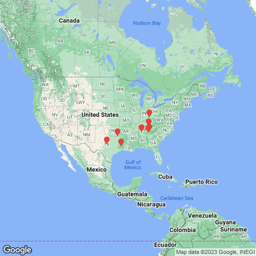
Range: Widespread in the Interior and Gulf Coastal Plain, eastern North America. Map of Georeferenced Specimens
 |
Genbank Vouchers
USAUF_438786 (QverRed015) (COI, ND1, ITS1, 5.8S) USA, Texas, Lamar County, Pine Creek, ~100 m upstream from CR906 (33.854656, -95.341305) UF_441208 (COI, ITS1, 5.8S) USA:Texas:Brown County:Colorado River downstream of Co. Rd. 229 (31.4831003, -99.0305955) UAUC_3195 (COI, 16S) Conasauga River, below Mitchell Bridge, Whitfield Co. GA FLMNH_439171 (SK19103) (COI, ND1) Sipsey River (33.121505, -87.911094) FLMNH_438746 (QverCol013) (COI, ND1) Llano River (30.658673, -99.3245) JBFMC_10005_1 (COI, 16S) USA: Texas, Little Brazos River UAUC_2753 (ND1) Cumberland R., Scott Co., Tennessee JFBM_23039 (SK19108) (COI) St. Croix River (45.394149, -92.663579) UAUC_40 (ND1) Elk R., Limestone Co., Alabama
UA_1350 (QverOhi048) (COI, ND1, ITS1, 5.8S) UMMZ_62984 (COI) UA_1350 (SRA)
|


