|
Bivalvia | Unionoida | Hyrioidea | Hyriidae | Velesunioninae | Alathyria species Alathyria profuga (Gould, 1850): specimens
2 nominal species as synonyms
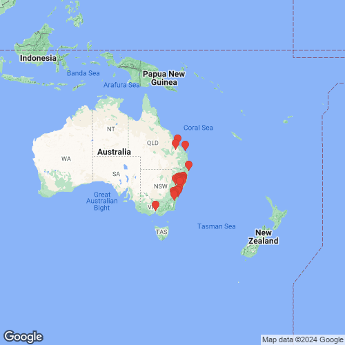
Range: Hunter and Shoalhaven rivers, New South Wales, Australia. Map of Georeferenced Specimens
 |
Australia |

AMS_113810
Paterson River, Lostock Dam, Gulgong Shire, New South Wales, Australia [-32.331, 151.448 ± 1 km]
|

AMS_47322
Hunter River, New South Wales, Australia [-32.467, 150.95 ± 100 km]
|

AMS_126343
Muswellbrook, Hunter River, New South Wales, Australia [-32.267, 150.9 ± 10 km]
|

AMS_47323
Paterson River, New South Wales, Australia [-32.167, 151.417 ± 100 km]
|

AMS_126104
Williams River at Dungog, New South Wales, Australia [-32.398, 151.763 ± 10 km]
|

AMS_61855
Hunter River at Muswellbrook, New South Wales, Australia [-32.267, 150.883 ± 10 km]
|

AMS_126228
Williams River, Dungog (In mud), New South Wales, Australia [-32.398, 151.763 ± 10 km]
|

AMS_126228B
Williams River, Dungog, new south wales
|

AMS_36550
Barrington River, New South Wales, Australia [-31.967, 151.732 ± 100 km]
|

AMS_404244
Gloucester. Creek west side of town adjacent to camping area, New South Wales, Australia [-32.005, 151.968 ± 10 km]
|

AMS_411896
S of Braidwood, on Krawarree Rd, Back Ck, New South Wales, Australia [-35.505, 149.698 ± 100 m]
|

AMS_61904
Hunter River at Muswellbrook, New South Wales, Australia [-32.267, 150.883 ± 10 km]
|

AMS_61851
W of Gloucester, upper Hunter River at Belltrees Stn, New South Wales, Australia [-31.996, 151.126 ± 1 km]
|

AMS_126369
Muswellbrook, Hunter River, New South Wales, Australia [-32.267, 150.883 ± 10 km]
|

AMS_47324
“?” [presumably Australia]
|

AMS_41284
Hunter River, New South Wales
|

AMS_404243
Sandy Hollow #1, Goulburn River Valley, archaeological rock shelter surface, New South Wales, Australia [-32.333, 150.567 ± 10 km]
|

AMS_18121-F
Cuan Creek, 20 mi W Scone, New South Wales
|

BMNH_89-10-25-5-7
Kangaroo River
|

HYR014
Wiliams River at Tillegra
|

BMNH_MP_140
Clarence River, NSW
|

BMNH_MP_141
Shoalhaven River
|

ZMB_46237
Burnett River, Queensland
|

BMNH_MP_146
Kangaroo River, Wallongong, NSW
|

BMNH_42-11-16-1
Australia
|

BMNH_88-11-28-1-3
Bylong [?] Creek head of Hunter Avon River, NSW
|

MNHN_MP_1539
Melbourne
|

MCZ_221445
Williams River, at Dungog, New South Wales, Australia
|

MCZ_191965
Paterson River, New South Wales, Australia
|

USNM_5928
Hunter’s R. N.S.Wales
|

AMNH_30902
Australia
|

AMS_61860
Shoalhaven River, New South Wales, Australia [-34.8, 150.317 > ± 100 km]
|

ANSP_67782
Hunter River
|

MNHN_MP_1461
Williams River, Dungog, New South Wales, Australia
|

UMMZ_304513
Mammy Johnson River, 10 km E Wards River, New South Wales, Australia, -32.24361°, 151.97556°
|

UMMZ_304514
Williams River, Tillegra, New South Wales, Australia
|

BMNH_MP_182
Bomaderry Creek, near Nowra, NSW
|

ANSP_125851
N.S.W.
|

MCZ_MP.238
Dawson River, Moura, Queensland, Australia
|

SBMHN_367471
S of Rockhampton, Queensland
|

AMS_47308
Shoalhaven River, New South Wales, Australia [-34.8, 150.317 > ± 100 km]
|

AMS_126246
NNW of Dungog, Williams River, on "Canningalla" property, Bandon Grove (Mud flats after floods), New South Wales, Australia [-32.311, 151.708 ± 1 km]
|

AMS_47310
Shoalhaven River, New South Wales, Australia [-34.8, 150.317 > ± 100 km]
|

AMS_12007
Kangaroo River, New South Wales, Australia [-34.683, 150.592 ± 100 km]
|

AMS_92303
W of Gloucester, upper Hunter River, Belltrees, New South Wales, Australia [-31.993, 151.125 ± 10 km]
|

AMS_173351
Creek off Wollombi River off Cessnock Road (Trails in sand), New South Wales, Australia [-32.883, 151.183 ± 10 km]
|

AMS_174668
Gloucester. Creek west side of town adjacent to camping area, New South Wales, Australia [-32.005, 151.968 ± 10 km]
|

AMS_61853
Lake George, New South Wales, Australia [-35.083, 149.417 ± 10 km]
|

AMS_62147
NNW of Nowra, Kangaroo Valley, New South Wales, Australia [-34.737, 150.533 ± 10 km]
|
|
|
|
AMS_421932 Dungog, Williams R between railway bridge and rd bridge beside park, New South Wales, Australia [-32.397, 151.762 ± 100 m]
AMS_432165 Hunter Region, Glennies Ck, W of Singleton at New England Hwy crossing (Partly buried in muddy gravel near bank, moderate flow), New South Wales, Australia [-32.476, 151.087 ± 100 m]
AMS_432166 Hunter Region, Stewarts Brook at Town Reserve and ford (Fast flowing, gravel bottom), New South Wales, Australia [-32.003, 151.309 ± 100 m]
AMS_422533 Hunter region: Fal Brook at Bowmans Ck Rd (Goorangoola Rd) crossing at Mt Pleasant, N of Singleton (Partially buried in mud amongst rocks), New South Wales, Australia [-32.41, 151.193 ± 100 m]
AMS_425849 Jerrys Plains Weir, New South Wales, Australia [-32.451, 150.934 ± 10 km]
AMS_311583 Little Manning R. at crossing on Nowendoc Rd. N. of Gloucester (Med. river with sand, gravel, boulders, mud.), New South Wales, Australia [-31.842, 151.883 ± 100 m]
AMS_431982 Millers Ck, on Bunkers Hill Rd, trib of Barrengary Ck, New South Wales, Australia [-34.683, 150.53 ± 1 km]
AMS_423845 Mongarlowe River, Charleyong, New South Wales, Australia [-35.253, 149.919 ± 1 km]
AMS_126388 Muscle Creek, Muswellbrook, New South Wales, Australia [-32.273, 150.893 ± 10 km]
AMS_126449 Muswellbrook, Hunter River, New South Wales, Australia [-32.267, 150.883 ± 10 km]
AMS_173165 Muswellbrook, Hunter River, New South Wales, Australia [-32.267, 150.883 ± 10 km]
AMS_425868 Rouchel Brook, New South Wales, Australia [-32.133, 151.067 ± 100 km]
AMS_405624 Shoalhaven River at ford on Wyanbene Caves Rd (Stony stream with some sand), New South Wales, Australia [-35.75, 149.65 ± 1 km]
AMS_202379 Williams R between rail bridge & road bridge crossings, Dungog (On bank), New South Wales, Australia [-32.397, 151.764 ± 100 m]
AMS_425882 Williams R, N of Clarence Town, Mill Flat Falls, New South Wales, Australia [-32.56, 151.8 ± 1 km]
AMS_426821 near Cessnock, W of Milfield, Wollombi Rd, Wollombi Brook N Arm, at Cedar Rd crossing, New South Wales, Australia [-32.937, 151.14 ± 1 km]
|
Genbank Vouchers
UMMZ_304514 (COI, 16S, 28S) UMMZ_304513 (COI, 16S, 28S)
|