|
Unionoida | Unionoidea | Unionidae | Gonideinae | Contradentini | Physunio species Physunio modelli Brandt, 1974: specimens
1 nominal species
Taxonomic History (since 2007)
Physunio modelli — Graf & Cummings (2007), Bogan (2010), IUCN (2012), Lopes-Lima et al. (2017), ..., Graf & Cummings (2021), Jeratthitikul et al. (2021), Bolotov et al. (2022), Konopleva et al. (2023)
Contradens sp. — Pfeiffer & Graf (2015), Konopleva et al. (2017)
Physunio cf. modelli — Bolotov et al. (2017)
Contradens sp. 1 — Bolotov et al. (2017)
Physunio sp. ‘Contradens’ — Bolotov et al. (2017), Bolotov et al. (2018), Huang et al. (2019), Konopleva et al. (2019), Konopleva et al. (2019), Bolotov et al. (2020)
Physunio sp. 2 — Wu et al. (2021)
|
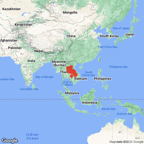
Range: Mekong Basin, Indochina. Map of Georeferenced Specimens
 |
Cambodia |

UF_507407
Unknown tributary of Mekong just N of Phumi Prêk Preah on AH11. CA16-06. 13.15123, 106.14521
|

UMMZ_304653
Pursat River, just downstream (north) of Highway 5 bridge, Pursat City, Cambodia 12.53308 103.91947
|

UA_21038
Beung Dang Teuk Leach Community Fishery Pursat Province, Cambodia
|

UF_507383
Tonle Srepok River, major bridge crossing on road from Stung Treng to Ban Lung. Srae Angkrorng, Ratanakiri, Cambodia. CA16-01. 13.44339, 106.60329
|

BMNH_MP_D369
Lao Mountains
|

UF_507389
Tonle Sekong River, 1.6 miles upstream from AH11 Bridge. CA16-03. 13.54504, 106.01353
|

MNHN_MP_3856
de Cambodge, Siam
|
|
|
Laos |

ANSP_H19006
Mekong River, Tateng, near Pakse, Laos
|

ANSP_H19018
Laos: Mekong at Pakse
|

MNHN_MP_3568
Menam, Laos
|
Thailand |

MNHN_MP_3087
Pong River at Pong Nip Dam, Kaen Province, Thailand
|

ANSP_H18992
Klong Sam Mo at Kro Rapids, Ban Sam Mo Chaiyapum Province, Thailand
|

SMRL_2484
Maenam Pong, Pa NokKao; Thailand
|

ANSP_H19009
Huai Ya, Gaeng Kro, Chaijapum, Thailand
|

ANSP_H19010
Thailand: Pibun, Huai Gaeng Yang, near Chong Mek
|

ANSP_H19011
Thailand: Loei Prov., Maenam Pong at Ban Pa Nok Kao
|

ANSP_H19012
Thailand: Lam Pao at Kalasin
|

ANSP_H19013
Lam Chi River, Mahachanachai, Ubon Ratchathani, Thailand
|

ANSP_H19014
Thailand: Songkram River at Wannonivat [= Wanon Niwat], Sakon Nakon Prov.
|

ANSP_H19015
Huai Sam Mo at Kro Rapids near Bang Gaeng Kro, Chaiyapum Province, Thailand
|

UF_346063
Thailand, Khon Kaen Province, 1.4km E intersection Highways 2038 and 12 Deep Muddy river, red clay banks, on rocks, wood and silty bottom 220 meters, 16.4833°, 102.4167°
|

SMF_188871
Lam Chi river at Ta Sabaeng, Roi Ett
|

ANSP_336141
Lam Chi at Amphoe Kosum Phisai (on HWY 208, about 34 km due SE of Khon Kaen
|

SMF_188873
Mun River at Ban Ta Thum, Surin
|

SMF_188874
Klong Sam Mo; Distr. Gaeng Kro; Prov. Chiayapum
|

SMF_188875
Pong river, Bridge Highway 27, N of Kon Gaen
|

SMF_188876
Pong River, Near Dam N Kon Gaen
|

USNM_786258
Huai Gaeng Yang, Pibun Mangsahan, Chong Mek, Ubon Province, Thailand
|

SMF_188877
Lam Pao (Lam Than) Prov. Kalasin
|

SMF_188878
Lam Chi River, Mahachanachai, Ubon Prov.
|

SMF_188879
Maenam Choen, W Kon Gaen
|

SMF_188880
Mun River bei Rasi Salai; Sri Saket
|

UF_507843
Khulu River at Rt. 2050 bridge approx. 9.5 km SSW of Trakan Phuet Phon. TH16-51. 15.547125, 104.976925
|

UF_507465
Mun River, 2.8 km North of Ban Taklang in Na Nong Phai. JMP17-32. 15.29274, 103.50744
|

SMF_319377
Thailand Pao (Lam Tum) at Kalasin
|

SMF_319378
Thailand: Mun River Ban Ta Thum, Surin
|

SMF_319379
Maenam Pong at Pa Nok Kao
|

SMF_319380
Pong River dam N Kon Kaen
|

UF_507602
Mun River at confluence with Chi River. TH15-01. 15.18188, 104.71430
|

UF_507863
Dom Yai River at Rt. 2248 bridge approx. 15 km ESE of Nam Yuen. TH16-59. 14.445989, 105.121116
|

UF_507737
Loei River at bridge S of Ban Wang Saphung. TH16-20. 17.288, 101.766
|

UF_507485
Chi River off of Hwy 202 in Lat Yai. JMP17-36. 15.75328, 102.25225
|

UF_507614
Mun River. TH15-04. 15.31534, 103.62985
|

MNHN_MP_2793
Klong Sam Mo at Gaeng Kro, Ban Sam Mo Chaiyapum Province, Thailand
|

UF_507489
Chi River downstream of HWY 225 in Talat Raeng. JMP17-37. 15.76964, 101.81476
|

UF_507745
Kong Si River at bridge ESE of Ban Kumphawapi. TH16-21. 17.097, 102.989
|

UF_507624
Pao River, trib. of Chi River at Rt. 214 bridge; Mun River drainage. TH15-06. 16.34022, 103.57584
|

USNM_786310
Klong Sam Mo, Gaeng Kro, Thailand
|

USNM_786318
Klong Sam Mo at Gaeng Kro, Ban Sam Mo Chaiyapum Province, Thailand
|

TMMUBI_171
Lom Dom Yai River
|

UF_507768
Songkhram River at bridge W of Ban Na Si Nuan on Rt. 2281. TH16-30. 17.729, 103.411
|

UF_507515
Chakkarat River at Rt. 226 in Nong Phluang. JMP17-48. 15.05821, 102.39806
|

SMF_205128
Thailand: Pong river at Ban Pa Nok Kao, Loei
|

SMF_220841
Thailand: Maenam Pong at Pong Nip Dam; Prov. Kon Kaen
|
|
|
UF_346061_02 Thailand, Khon Kaen Province, 1.4km E intersection Highways 2038 and 12 Deep Muddy river, red clay banks, on rocks, wood and silty bottom 220 meters, 16° 29' N, 102° 25' E
|
Genbank Vouchers
CambodiaUMMZ_304653 (COI, 16S, 28S) Pursat River, just downstream (north) of Highway 5 bridge, Pursat City, Cambodia 12.53308 103.91947 UF_507383 (ICH-00421) (COI) Cambodia, Tonle Srepok River, major bridge crossing on road from Stung Treng to Ban Lung (13.443388, 106.603294) UF_507383 (ICH-00419) (COI) Cambodia, Tonle Srepok River, major bridge crossing on road from Stung Treng to Ban Lung (13.443388, 106.603294) UF_507389 (ICH-00439) (COI) Cambodia, Tonle Sekong River, 1.6 miles upstream from AH11 Bridge (13.545038, 106.013527) UF_507389 (ICH-00440) (COI) Cambodia, Tonle Sekong River, 1.6 miles upstream from AH11 Bridge (13.545038, 106.013527) UF_507383 (ICH-00420) (COI) Cambodia, Tonle Srepok River, major bridge crossing on road from Stung Treng to Ban Lung (13.443388, 106.603294)
ThailandMUMNH_UNI0557 (COI, 16S, 28S, H3) Songkhram River at Ban Ya, Nong Han, Udon Thani, Thailand (17° 23' 44.5" N, 103° 18' 01.7" E) RMBH_biv_125_2 (COI, 16S, 28S) Thailand: Mekong River basin, Chi River RMBH_biv_125_3 (COI, 16S, 28S) Thailand: Mekong River basin, Chi River RMBH_biv_205_1 (COI, 28S) Thailand: Mekong River basin, Phong River RMBH_biv_205_2 (COI, 28S) Thailand: Mekong River basin, Phong River RMBH_biv_131 (COI, 28S) Thailand: Mekong River basin, Chi River UF_507489 (ICH-02154) (COI, SRA) Thailand, Chi River downstream of HWY 225 in Talat Raeng (15.76964, 101.81476) RMBH_biv_205_3 (COI, 28S) Thailand: Mekong River basin, Phong River RMBH_biv_131_3 (COI, 28S) Thailand: Mekong River basin, Chi River RMBH_biv_131_1 (COI, 28S) Thailand: Mekong River basin, Chi River RMBH_biv_131_2 (COI, 28S) Thailand: Mekong River basin, Chi River UF_507614 (2014-0597) (COI) Thailand, Mun River (15.315337, 103.62985) UF_507737 (ICH-00704) (COI) Thailand, Loei River at bridge S of Ban Wang Saphung (17.287783, 101.765735) UF_507768 (ICH-00784) (COI) Thailand, Songkhram River at bridge W of Ban Na Si Nuan on Rt. 2281 (17.72947, 103.410732) UF_507489 (ICH-02155) (COI) Thailand, Chi River downstream of HWY 225 in Talat Raeng (15.76964, 101.81476) UF_507489 (ICH-02153) (COI) Thailand, Chi River downstream of HWY 225 in Talat Raeng (15.76964, 101.81476) UF_507745 (ICH-00720) (COI) Thailand, Kong Si River at bridge ESE of Ban Kumphawapi (17.09692, 102.988512) UF_507768 (ICH-00786) (COI) Thailand, Songkhram River at bridge W of Ban Na Si Nuan on Rt. 2281 (17.72947, 103.410732) UF_507602 (2014-0560) (COI) Thailand, Mun River at confluence with Chi River (15.18188, 104.7143) UF_507515 (ICH-02186) (COI) Thailand, Chakkarat River at Rt. 226 in Nong Phluang (15.058209, 102.398061) UF_507737 (ICH-00703) (COI) Thailand, Loei River at bridge S of Ban Wang Saphung (17.287783, 101.765735) UF_507465 (ICH-02115) (COI) Thailand, Mun River, 2.8 km North of Ban Taklang in Na Nong Phai (15.29274, 103.50744) UF_507768 (ICH-00785) (COI) Thailand, Songkhram River at bridge W of Ban Na Si Nuan on Rt. 2281 (17.72947, 103.410732) UF_507485 (ICH-02147) (COI) Thailand, Chi River off of Hwy 202 in Lat Yai (15.75328, 102.25225) UF_507737 (ICH-00705) (COI) Thailand, Loei River at bridge S of Ban Wang Saphung (17.287783, 101.765735) UF_507745 (ICH-00721) (COI) Thailand, Kong Si River at bridge ESE of Ban Kumphawapi (17.09692, 102.988512) UF_507614 (2014-0595) (COI) Thailand, Mun River (15.315337, 103.62985) UF_507614 (2014-0594) (COI) Thailand, Mun River (15.315337, 103.62985) UF_507863 (ICH-01198) (COI) Thailand, Dom Yai River at Rt. 2248 bridge approx. 15 km ESE of Nam Yuen (14.445989, 105.121116) UF_507768 (ICH-00787) (COI) Thailand, Songkhram River at bridge W of Ban Na Si Nuan on Rt. 2281 (17.72947, 103.410732) UF_507624 (2014-0619) (COI) Thailand, Pao River, trib. of Chi River at Rt. 214 bridge; Mun River drainage (16.34022, 103.57584) UF_507624 (2014-0621) (COI) Thailand, Pao River, trib. of Chi River at Rt. 214 bridge; Mun River drainage (16.34022, 103.57584) UF_507863 (ICH-01200) (COI) Thailand, Dom Yai River at Rt. 2248 bridge approx. 15 km ESE of Nam Yuen (14.445989, 105.121116) UF_507485 (ICH-02148) (COI) Thailand, Chi River off of Hwy 202 in Lat Yai (15.75328, 102.25225) UF_507745 (ICH-00722) (COI) Thailand, Kong Si River at bridge ESE of Ban Kumphawapi (17.09692, 102.988512) UF_507745 (ICH-00719) (COI) Thailand, Kong Si River at bridge ESE of Ban Kumphawapi (17.09692, 102.988512) UF_507624 (2014-0620) (COI) Thailand, Pao River, trib. of Chi River at Rt. 214 bridge; Mun River drainage (16.34022, 103.57584) UF_507863 (ICH-01199) (COI) Thailand, Dom Yai River at Rt. 2248 bridge approx. 15 km ESE of Nam Yuen (14.445989, 105.121116) UF_507485 (ICH-02146) (COI) Thailand, Chi River off of Hwy 202 in Lat Yai (15.75328, 102.25225) UF_507614 (2014-0596) (COI) Thailand, Mun River (15.315337, 103.62985)
|